 | 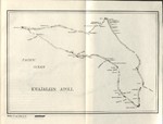 | 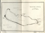 | 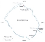 |
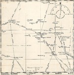
| United States Hydrographic Office July 1943 map of the Marshall Islands showing distances and bearings between major island groups. | 1944 United States Navy chart of Kwajalein Atoll, Marshall Islands. | 1944 United States Navy chart of Majuro Atoll, Marshall Islands. | Feb 1944 United States Army map of Eniwetok Atoll in the Marshall Islands. |
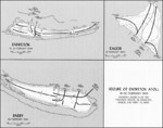 | |||
| Map illustrating Operation Catchpole against Eniwetok, Engebi, and Parry Islands of Eniwetok Atoll, Marshall Islands, 18-22 Feb 1944 |
Pesquisar WW2DB
Notícias
- » Wreck of M-49 Found (10 Apr 2025)
- » Japanese Emperor Visited Iwoto (Iwo Jima) (8 Apr 2025)
- » Race, Holocaust, and African-American WW2 Histories Removed from the US Naval Academy Library (7 Apr 2025)
- » US Government Plans to Purge WW2 Information (17 Mar 2025)
- » Ver todas as notícias
Estatísticas Atuais do Site
- » 1,167 biographies
- » 337 events
- » 44,607 timeline entries
- » 1,243 ships
- » 350 aircraft models
- » 207 vehicle models
- » 376 weapon models
- » 123 historical documents
- » 261 facilities
- » 470 book reviews
- » 28,503 photos
- » 365 maps
Citação Famosa da 2ª GM
"All that silly talk about the advance of science and such leaves me cold. Give me peace and a retarded science."Thomas Dodd, late 1945
Apoie-nos
Por favor, considere nos apoiar no Patreon. Mesmo R$1 por mês já faz uma grande diferença. Obrigado!
Ou, por favor, nos apoie adquirindo alguns produtos do WW2DB na TeeSpring. Obrigado!