 |  |  |  |
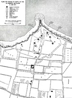
| 1944 United States Army map of the Army Rangers’ attack plan for Pointe du Hoc on the Normandy beaches set for 6 Jun 1944. Note the misspelling of Pointe du Hoc. | Map noting situation at Normandy, France at 2400 hours on 6 Jun 1944; note title text with deceptive American unit FUSAG | Map of Allied assault routes at Normandie, France, 6 Jun 1944 | Map of Juno Beach Normandy, France showing 3rd Canadian Infantry Division D-Day landing objectives and front line as of midnight 6 Jun 1944. |
 |  | 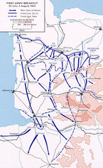 |  |
| Map showing German dispositions on Cotentin Peninsula in France on 6 Jun 1944 | US Army map of the landing beaches at Utah Beach, Normandy, France, 6 Jun 1944. Note that the planned landing beaches are about 250 yards away from actual landing beaches. | Map depicting the US 1st Army's breakout in Normandy, France, 24 Jul-4 Aug 1944 | Map depicting US Army VII Corps advancing into Brittany, France, 1-12 Aug 1944 |
 |  |  | 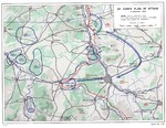 |
| Strategic map of the United States Navy’s actions during the landings in Southern France, 15 Aug 1944. | Map depicting the US 7th Army's front in Southern France, 1 Sep 1944 | Map depicting the western front of the European War, 1 Sep 1944 | Map showing the plan of attack for US Army XII Corps on the city of Nancy, France, Sep 4, 1944. |
 | 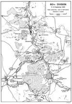 | 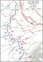 |  |
| Map depicting the German front in Northeastern France, 5 Sep 1944 | Map showing the plan of attack for US Army 80th Division on the city of Nancy, France, Sep 5-10, 1944. | Map depicting the US 3rd Army's front lines at the evening of 25 Sep 1944 | Map depicting the US 3rd Army's November Offensive, 8 Nov-2 Dec 1944 |
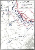 |  | ||
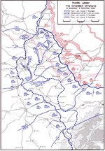
| Map depicting the US 3rd Army's Lorraine Offensive, 3-19 Dec 1944 | Graphic chart of Allied advance in France, from Fiscal Years 1944-1945 Biennial Report of Army Chief from Staff General George Marshall to the US Secretary of War, Aug 1945 |
Pesquisar WW2DB

Notícias
- » Wreck of Teruzuki Found (27 jul 2025)
- » USS Orlean's Bow Found (22 jul 2025)
- » The Emperor of Japan Planned to Honor WW2-era Japanese POWs in Mongolia (4 jul 2025)
- » US State Lawmaker John Winter Caught Using Racial Slur "Jap" and Apologized (11 jun 2025)
- » US Government Plans to Purge WW2 Information (17 mar 2025)
- » Ver todas as notícias
Estatísticas Atuais do Site
- » 1,182 biografias
- » 337 eventos
- » 45,119 entradas na linha do tempo
- » 1,248 navios
- » 350 modelos de aeronaves
- » 207 modelos de veículos
- » 376 modelos de armas
- » 123 documentos históricos
- » 261 instalações
- » 470 resenhas de livros
- » 28,411 fotos
- » 365 mapas
Citação Famosa da 2ª GM
"All right, they're on our left, they're on our right, they're in front of us, they're behind us... they can't get away this time."Lt. Gen. Lewis B. "Chesty" Puller, at Guadalcanal
Apoie-nos
Por favor, considere nos apoiar no Patreon. Mesmo R$1 por mês já faz uma grande diferença. Obrigado!
Ou, por favor, nos apoie adquirindo alguns produtos do WW2DB na TeeSpring. Obrigado!