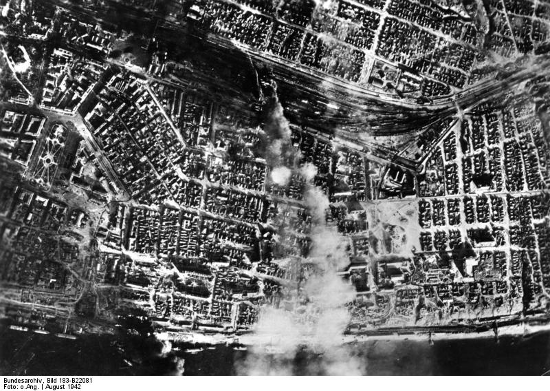
| Caption | Aerial view of Stalingrad from a German bomber, Russia, Aug 1942 ww2dbase | ||||
| Photographer | Unknown | ||||
| Source | ww2dbaseGerman Federal Archives | ||||
| Identification Code | Bild 183-B22081 | ||||
| More on... |
| ||||
| Photo Size | 800 x 568 pixels | ||||
| Photos at Same Place | Stalingrad, Russia | ||||
| Added By | C. Peter Chen | ||||
| Licensing | Creative Commons Attribution ShareAlike 3.0 Germany License (CC BY-SA 3.0 DE).
See Bild 183-B22081 on Wikimedia Commons According to the German Federal Archive (Bundesarchiv), as of 21 Jul 2010, photographs can be reproduced with if these preconditions are met: - add the signature of the pictures and - of name of the originator, i.e. the photographer. ... You also can use fotos from the Federal Archives for free on Wikimedia Commons http://commons.wikimedia.org/wiki/Commons:Bundesarchiv Please contact us regarding any inaccuracies with the above information. Thank you. |
Did you enjoy this photograph or find this photograph helpful? If so, please consider supporting us on Patreon. Even $1 per month will go a long way! Thank you. Share this photograph with your friends: Stay updated with WW2DB: |
Visitor Submitted Comments
2. Mark Prange says:
7 Apr 2013 05:24:43 AM
(On the right hand side of the webpage), the Modern Day Location (Satellite) zooms in on Pavlov's House.
7 Apr 2013 05:24:43 AM
(On the right hand side of the webpage), the Modern Day Location (Satellite) zooms in on Pavlov's House.
3. Mark Prange says:
5 May 2013 01:27:41 PM
An aerial photograph of this area after the battle is online at Stalingrad Aerial Scans.
GX2839SD-570
5 May 2013 01:27:41 PM
An aerial photograph of this area after the battle is online at Stalingrad Aerial Scans.
GX2839SD-570
4. Mark Prange says:
10 Jun 2013 06:01:16 PM
The L-shaped (╔) house is 15% in from the right, 30% up from the bottom.
The train station's terminal building is 25% in from the left, 10% down from the top; the Barmalay sculpture is in the circular fountain across the open plaza there.
10 Jun 2013 06:01:16 PM
The L-shaped (╔) house is 15% in from the right, 30% up from the bottom.
The train station's terminal building is 25% in from the left, 10% down from the top; the Barmalay sculpture is in the circular fountain across the open plaza there.
All visitor submitted comments are opinions of those making the submissions and do not reflect views of WW2DB.
Search WW2DB
Modern Day Location
| WW2-Era Place Name | Stalingrad, Stalingrad, Russia |
| Lat/Long | 48.7160, 44.5315 |
Random Photograph
Current Site Statistics
- » 1,150 biographies
- » 337 events
- » 44,024 timeline entries
- » 1,242 ships
- » 350 aircraft models
- » 207 vehicle models
- » 375 weapon models
- » 123 historical documents
- » 260 facilities
- » 470 book reviews
- » 28,613 photos
- » 432 maps
Famous WW2 Quote
"You ask, what is our aim? I can answer in one word. It is victory. Victory at all costs. Victory in spite of all terrors. Victory, however long and hard the road may be, for without victory there is no survival."Winston Churchill
Support Us
Please consider supporting us on Patreon. Even $1 a month will go a long way. Thank you!
Or, please support us by purchasing some WW2DB merchandise at TeeSpring, Thank you!
14 Mar 2013 01:37:34 PM
This shows Railroad Station No. 1, Red Square (on the left), many boat landings along the Volga (at the bottom), 9th of January Square (the light colored square between the railyard and the river--to the right of the big smoke plume), Pavlov's House (of the two long buildings in the lower left of 9 January Square, it is the one on the right), and the Flour Mill (sometimes called the Grist Mill or Steam Mill) between Pavlov's House and the river--about 1/4 of the distance to the river.