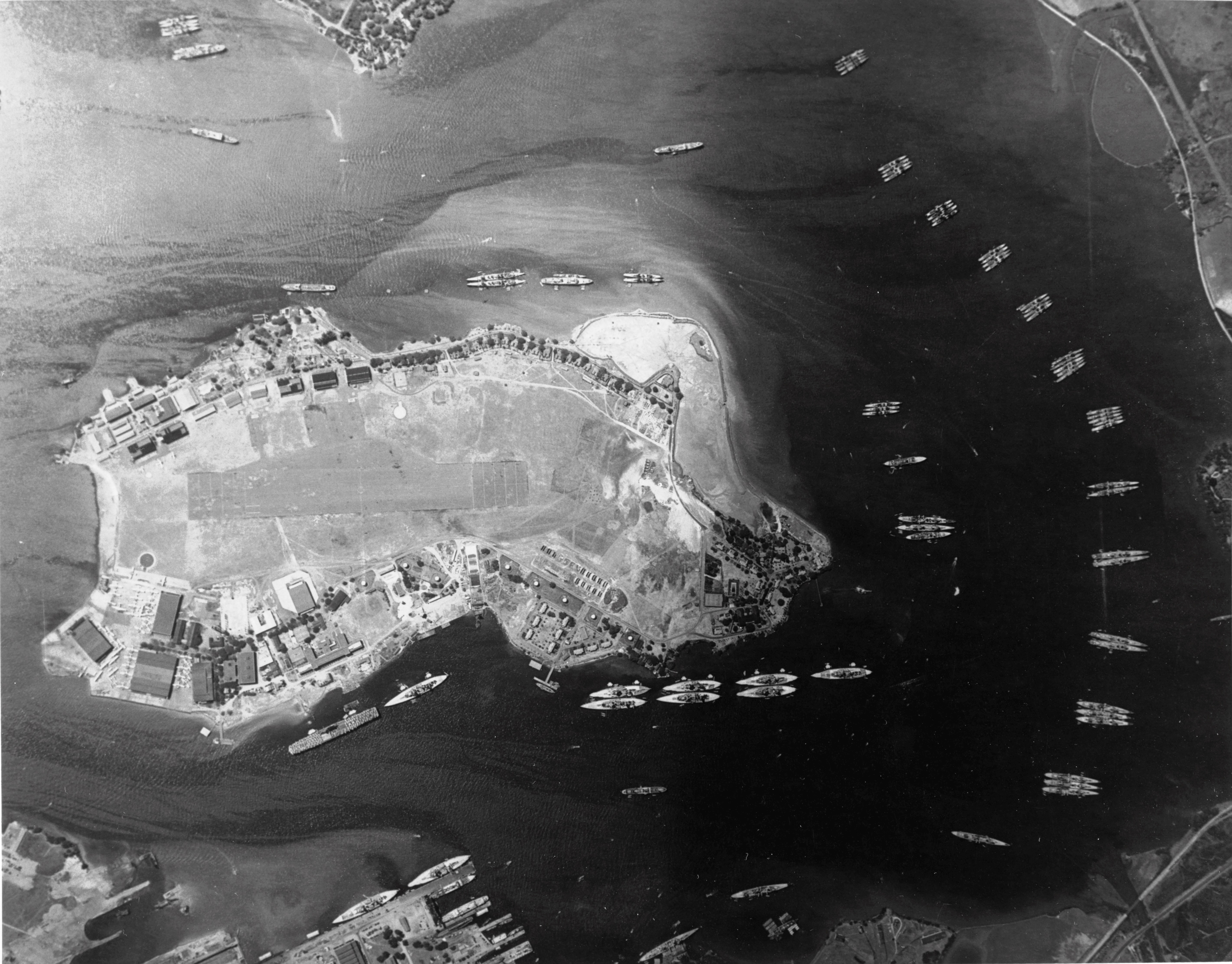
| Caption | Aerial view of Ford Island and Pearl Harbor’s East Loch anchorage, 3 May 1940. Note 8 battleships along Battleship Row and 2 more across the channel at the 1010 Dock. Note also carrier Yorktown (Yorktown-class). ww2dbase | ||||||||||||||||||||||||||||||||||
| Photographer | Unknown | ||||||||||||||||||||||||||||||||||
| Source | ww2dbaseUnited States Navy | ||||||||||||||||||||||||||||||||||
| Identification Code | 80-G-411117 | ||||||||||||||||||||||||||||||||||
| More on... |
| ||||||||||||||||||||||||||||||||||
| Photo Size | 5,681 x 4,445 pixels | ||||||||||||||||||||||||||||||||||
| Photos on Same Day | 3 May 1940 | ||||||||||||||||||||||||||||||||||
| Photos at Same Place | Honolulu, Oahu, Hawaii | ||||||||||||||||||||||||||||||||||
| Added By | David Stubblebine | ||||||||||||||||||||||||||||||||||
| Licensing | Public Domain. According to the United States copyright law (United States Code, Title 17, Chapter 1, Section 105), in part, "[c]opyright protection under this title is not available for any work of the United States Government". Please contact us regarding any inaccuracies with the above information. Thank you. |
||||||||||||||||||||||||||||||||||
| Colorized By WW2DB |
Colorized with Adobe Photoshop |
Você gostou deste artigo ou achou este artigo útil? Se sim, considere nos apoiar no Patreon. Mesmo USD $1 por mês já vai longe! Obrigado. Por favor, ajude-nos a espalhar a palavra: Fique atualizado com WW2DB: |
Visitor Submitted Comments
All visitor submitted comments are opinions of those making the submissions and do not reflect views of WW2DB.
Pesquisar WW2DB
Modern Day Location
| WW2-Era Place Name | Honolulu, Oahu, Hawaii |
| Lat/Long | 21.3681, -157.9532 |
Estatísticas Atuais do Site
- » 1,167 biographies
- » 337 events
- » 44,606 timeline entries
- » 1,243 ships
- » 350 aircraft models
- » 207 vehicle models
- » 376 weapon models
- » 123 historical documents
- » 261 facilities
- » 470 book reviews
- » 28,504 photos
- » 365 maps
Citação Famosa da 2ª GM
"I have returned. By the grace of Almighty God, our forces stand again on Philippine soil."General Douglas MacArthur at Leyte, 17 Oct 1944
Apoie-nos
Por favor, considere nos apoiar no Patreon. Mesmo R$1 por mês já faz uma grande diferença. Obrigado!
Ou, por favor, nos apoie adquirindo alguns produtos do WW2DB na TeeSpring. Obrigado!
16 Dec 2016 10:28:30 AM
This photo was taken from an altitude of 17,200 feet. There are also many cruisers and destroyers present as this photo was taken just after Fleet Problem XXI had concluded and just before the fleet’s station was officially relocated from San Diego to Pearl Harbor. The darker right half of this image is not a flaw in the photograph but because the East Loch was in the shadow of a cloud when the photo was taken. The official Navy caption for this image says there are 38 PBY patrol planes visible at the Seaplane Base on Ford Island (left) but there are not; there may be 38 aircraft visible but they are not all PBYs.