| Historical Information | ||||||
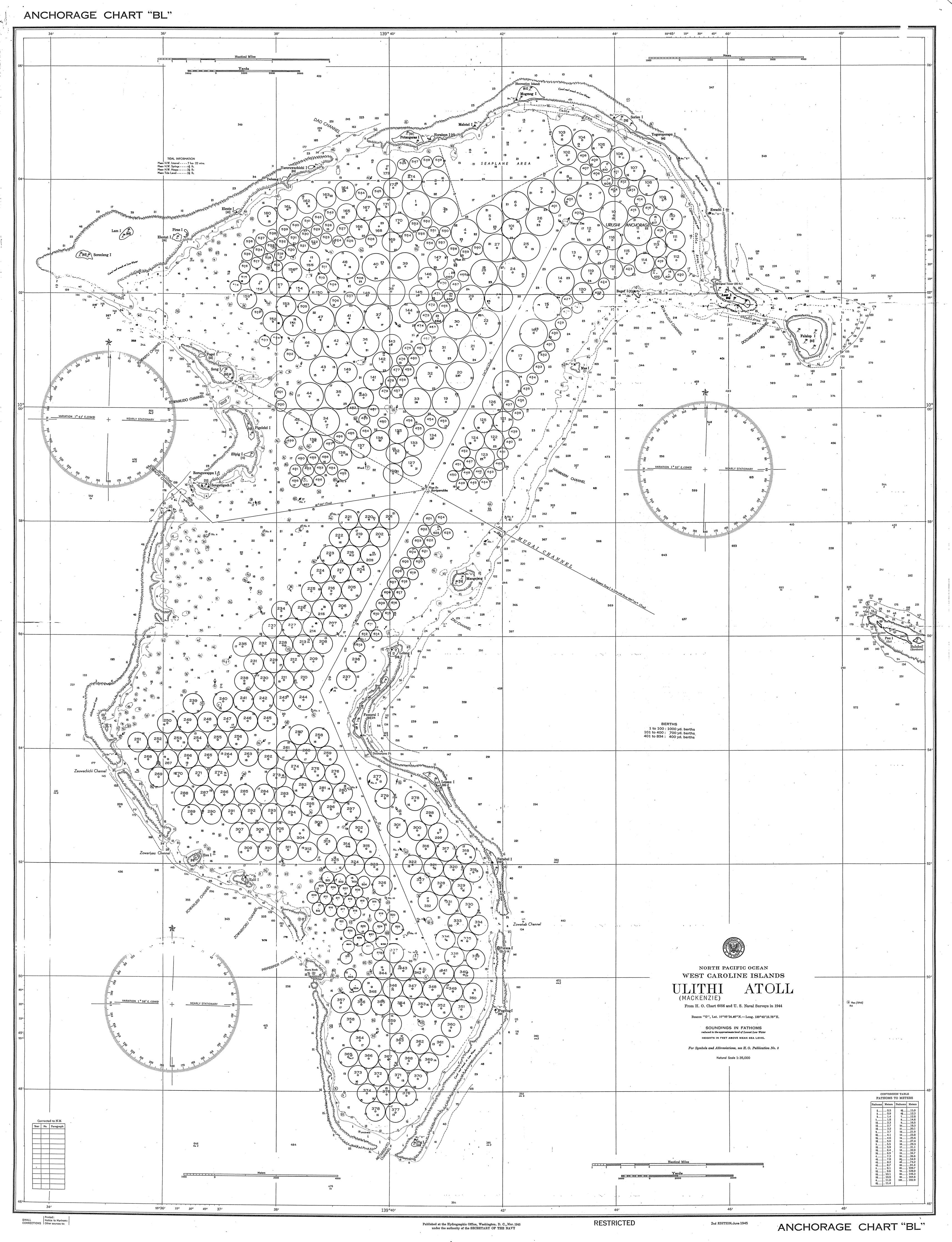
| Caption | US Navy Mooring Plan for Ulithi Lagoon, Caroline Islands, Jun 1945. Ships’ logs suggest there was an as yet unknown earlier mooring plan for Ulithi but this one was in use at least from Nov 1944. ww2dbase | |||||
| WW2-Era Location Name | Ulithi, Caroline Islands | |||||
| Date | Jun 1945 | |||||
| Photographer | Unknown | |||||
| Source Information | ||||||
| Source | ww2dbaseUnited States Navy via ussmississinewa.com | |||||
| Related Content | ||||||
| More on... |
| |||||
| Licensing Information | ||||||
| Licensing | Public Domain. According to the United States copyright law (United States Code, Title 17, Chapter 1, Section 105), in part, "[c]opyright protection under this title is not available for any work of the United States Government". Please contact us regarding any inaccuracies with the above information. Thank you. |
|||||
| Metadata | ||||||
| Added By | David Stubblebine | |||||
| Photo Size | 3,430 x 4,474 pixels | |||||
Você gostou deste artigo ou achou este artigo útil? Se sim, considere nos apoiar no Patreon. Qualquer valor já vai ajudar! Obrigado. Por favor, ajude-nos a divulgar o site: Fique atualizado com WW2DB: |
Visitor Submitted Comments
All visitor submitted comments are opinions of those making the submissions and do not reflect views of WW2DB.
Pesquisar WW2DB

Map
WW2-Era Location Name:Ulithi, Caroline Islands
Latitude-Longitude:
9.9333, 139.7000
Foto Aleatória
Estatísticas Atuais do Site
- » 1,181 biografias
- » 337 eventos
- » 45,111 entradas na linha do tempo
- » 1,246 navios
- » 350 modelos de aeronaves
- » 207 modelos de veículos
- » 376 modelos de armas
- » 123 documentos históricos
- » 261 instalações
- » 470 eventos
- » 28,473 fotos
- » 365 mapas
Citação Famosa da 2ª GM
"With Germany arming at breakneck speed, England lost in a pacifist dream, France corrupt and torn by dissension, America remote and indifferent... do you not tremble for your children?"Winston Churchill, 1935
Apoie-nos
Por favor, considere nos apoiar no Patreon. Mesmo R$1 por mês já faz uma grande diferença. Obrigado!
Ou, por favor, nos apoie adquirindo alguns produtos do WW2DB na TeeSpring. Obrigado!
18 Oct 2015 01:13:39 PM
Directly in line with the Mugai Channel just below Berth 137 is a marker titled “Wreck” on what is marked as a mount 7 fathoms deep. This is the wreck of the fleet oiler USS Mississinewa, sunk on 20 Nov 1944 as the first casualty of the Japanese Kaiten piloted torpedo program. The mooring plan initially included Berths, 129, 130, & 131 but these were eliminated from the plan because of the presence this wreck. Mississinewa had been in Berth 131.