| Historical Information | |||||||||||
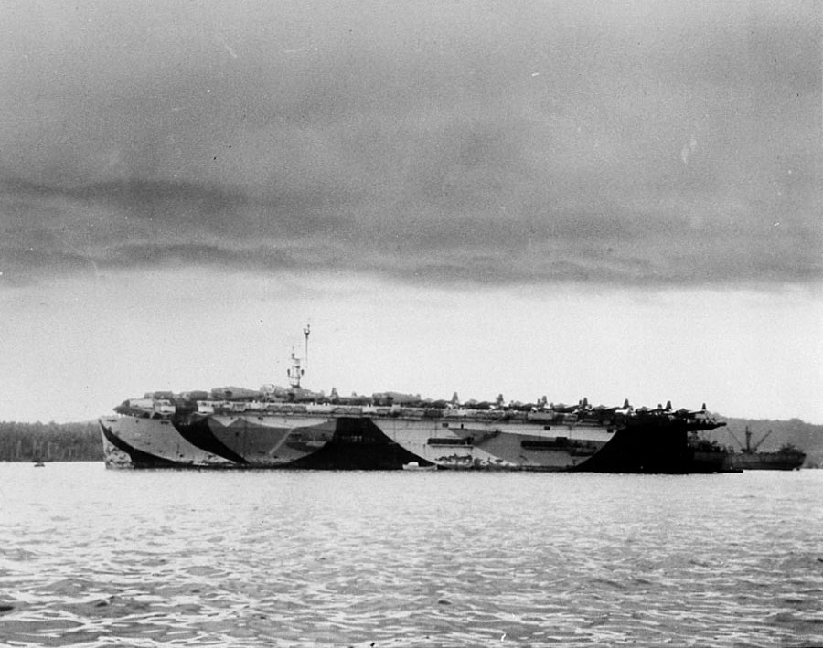
| Caption | USS Marcus Island at Espiritu Santo, 15 Jun 1944; note Camouflage Measure 32 Design 15A ww2dbase | ||||||||||
| WW2-Era Location Name | Palikulo Bay, Espiritu Santo, New Hebrides | ||||||||||
| Date | 15 Jun 1944 | ||||||||||
| Photographer | Unknown | ||||||||||
| Source Information | |||||||||||
| Source | ww2dbaseUnited States Navy Naval History and Heritage Command | ||||||||||
| Identification Code | NH 83286 | ||||||||||
| Related Content | |||||||||||
| More on... |
| ||||||||||
| Photos on Same Day | 15 Jun 1944 | ||||||||||
| Colorized By WW2DB |
Colorized with Adobe Photoshop |
||||||||||
| Licensing Information | |||||||||||
| Licensing | Public Domain. According to the US Navy Naval History and Heritage Command, as of 21 Jul 2010: Please contact us regarding any inaccuracies with the above information. Thank you. |
||||||||||
| Metadata | |||||||||||
| Added By | C. Peter Chen | ||||||||||
| Photo Size | 900 x 709 pixels | ||||||||||
Você gostou deste artigo ou achou este artigo útil? Se sim, considere nos apoiar no Patreon. Qualquer valor já vai ajudar! Obrigado. Por favor, ajude-nos a divulgar o site: Fique atualizado com WW2DB: |
Visitor Submitted Comments
2.  David Stubblebine says:
27 Apr 2020 11:33:48 PM
Rich Miller (above):
Your dates are correct and the caption has been updated. Thank you for pointing this out. Further, the Marcus Island war diaries say she loaded these aircraft on 15 Jun 1944 and departed from Espiritu Santo’s Palikulo Bay the following day. Except for getting the date wrong, the official Navy caption for this image still contains some interesting information. It reads:
“USS Marcus Island in a south Pacific port, 17 June 1944. The airplanes parked on her flight deck from amidships to the stern appear to be TDR-1 assault drones. She is probably delivering elements of Special Task Air Group One (STAG-1), which employed TDR-1s in Solomons area combat operations during September and October 1944. Other planes on board appear to be TBMs, which were used for drone control.”
All visitor submitted comments are opinions of those making the submissions and do not reflect views of WW2DB.
Pesquisar WW2DB

Map
WW2-Era Location Name:Palikulo Bay, Espiritu Santo, New Hebrides
Latitude-Longitude:
-15.4853, 167.2457
Estatísticas Atuais do Site
- » 1,181 biografias
- » 337 eventos
- » 45,132 entradas na linha do tempo
- » 1,249 navios
- » 350 modelos de aeronaves
- » 207 modelos de veículos
- » 376 modelos de armas
- » 123 documentos históricos
- » 261 instalações
- » 470 resenhas de livros
- » 28,427 fotos
- » 365 mapas
Citação Famosa da 2ª GM
"An appeaser is one who feeds a crocodile, hoping it will eat him last."Winston Churchill
Apoie-nos
Por favor, considere nos apoiar no Patreon. Mesmo R$1 por mês já faz uma grande diferença. Obrigado!
Ou, por favor, nos apoie adquirindo alguns produtos do WW2DB na TeeSpring. Obrigado!
27 Apr 2020 09:25:07 PM
Marcus Island (CVE-77) War History says she went underway from Espiritu Santo for San Diego on June 16 1944, arriving July 1, transporting aircraft back to the US. She was not assigned to a combat group until August 4 1944 when she reported to Commander Third Fleet and then to Task Group 19.1 at Pearl Harbor.