Guilin Airfield
| Type | 77 Air Base | |
| Historical Name of Location | Liangjiang, Guangxi, China | |
| Coordinates | 25.218056000, 110.039167000 |
Contributor: C. Peter Chen
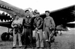
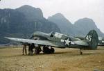
ww2dbaseThe Guilin Airfield (Postal Map romanization: Kweilin) in Guangxi Province in southern China. Between late 1943 and late 1944, it was used by US 23rd Fighter Group "Flying Tigers", flying P-40 Warhawk and P-51 Mustang fighters, and US 8th Reconnaissance Group, flying photographic reconnaissance variant of P-38 Lightning aircraft. Starting in late 1944, it was taken over by the Chinese-American Composite Wing, flying B-25 Mitchell bombers and P-51 Mustang fighters. The airfield was closed in Sep or Oct 1945. Today it is being used as the civilian Guilin Liangjiang International Airport.
ww2dbaseSource: Wikipedia
Last Major Update: Feb 2014
Guilin Airfield Mapa Interativo
Photographs
 |  |
Você gostou deste artigo ou achou este artigo útil? Se sim, considere nos apoiar no Patreon. Qualquer valor já vai ajudar! Obrigado. Por favor, ajude-nos a divulgar o site: Fique atualizado com WW2DB: |

Liangjiang, Guangxi, China
Latitude-Longitude:
25.2181, 110.0392
- » 1,182 biografias
- » 337 eventos
- » 45,119 entradas na linha do tempo
- » 1,248 navios
- » 350 modelos de aeronaves
- » 207 modelos de veículos
- » 376 modelos de armas
- » 123 documentos históricos
- » 261 instalações
- » 470 resenhas de livros
- » 28,410 fotos
- » 365 mapas
James Forrestal, Secretary of the Navy, 23 Feb 1945
Por favor, considere nos apoiar no Patreon. Mesmo R$1 por mês já faz uma grande diferença. Obrigado!
Ou, por favor, nos apoie adquirindo alguns produtos do WW2DB na TeeSpring. Obrigado!